
Hiking in Senja, Norway: Best Trails, Including Hesten & Segla
Senja is built for hiking. The mountains look crazy and drop straight into fjords; the trails are largely unmarked and uncrowded, and the views — on a clear day — are the perfect reward to a strenuous climbuncrowded;.

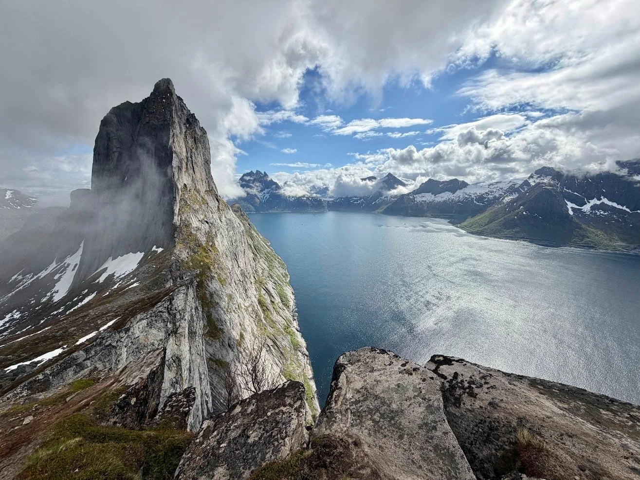
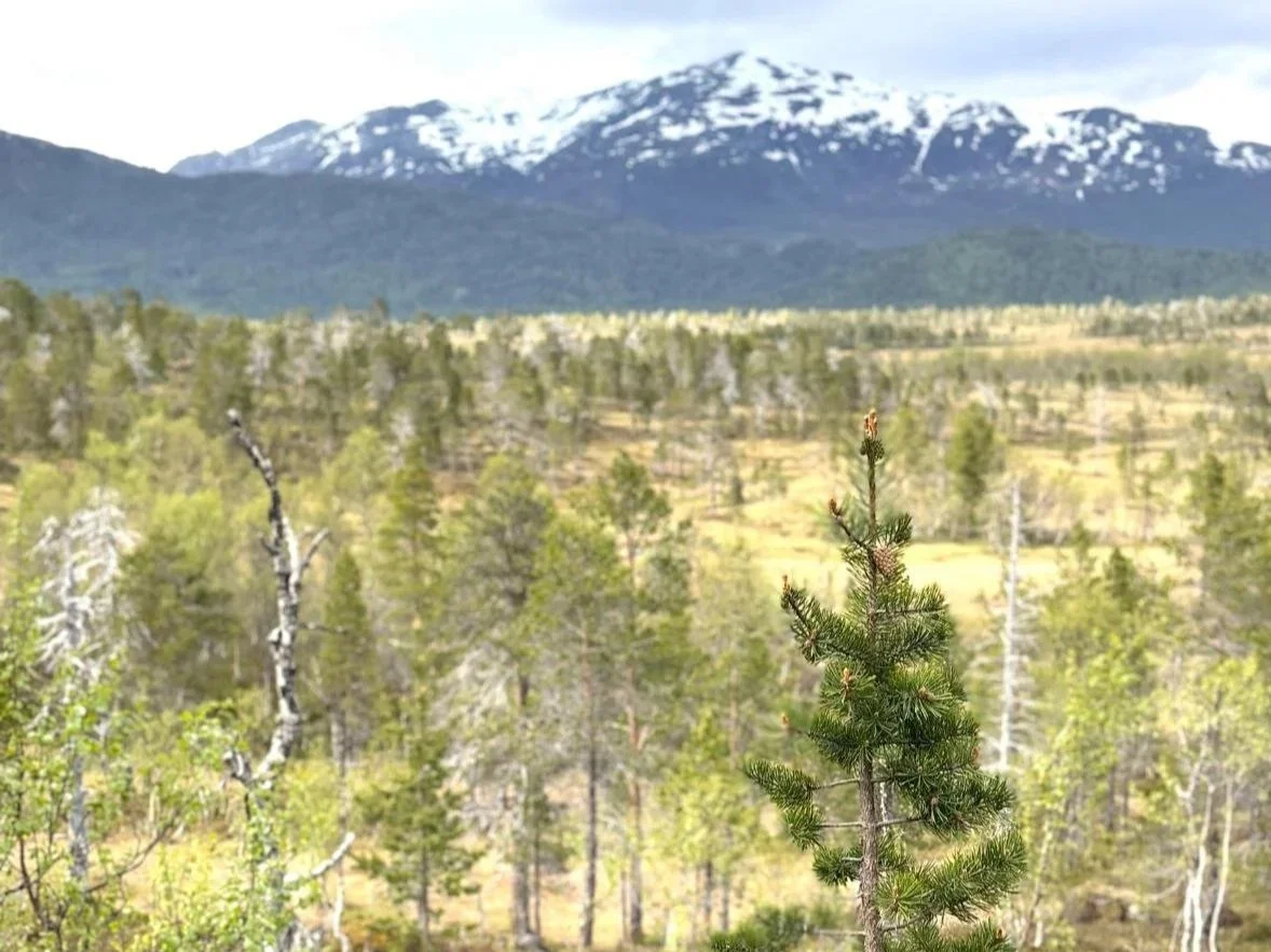
Taking photos of Hegla from Hesten before the clouds roll in!
We had four days on Senja, Norway, with variable weather and a rotating window of clear skies. We hiked Hesten, Husfjellet, Knuten above Mefjordvær, and Utsikten near Hamn i Senja. And we can’t wait to go back for more!
This Senja hiking guide covers those four trails from our own experience, plus the big ones we didn't do — Segla, Barden, and Breidtinden — because they deserve their own introduction.
Jump to: Hesten · Segla · Husfjellet · Knuten · Utsikten · Barden & Breidtinden · Guided tours · Practical tips · FAQ
Browse tours and activities in Senja:
Zoom in and out on the map below to find a hotel, cabin or apartment in Senja and around:
Compare rental cars in Tromsø:
Best hikes in Senja, Norway: Quick answer
The most iconic hike on Senja is probably Segla, a strenuous 5km trail from Fjordgård to a sail-shaped peak with a near-vertical cliff to the sea. Hesten, directly across from Segla, gives the best view of it — and is the one we actually hiked. Husfjellet near Skaland is a longer, wilder climb with 360° views across two fjords. For something short and memorable, Knuten above Mefjordvær takes 15 minutes and rewards you with open fjord views under the midnight sun. A rental car is essential — there's no public transport connecting Senja's trailheads. Most hikes are doable June to September; some are manageable year-round with snow shoes or skis, experience and/or a local guide.
🐧 Hikes we did on Senja
Hiking Hesten, Senja: the best view of Segla
Mighty Segla from Hesten ridge
📍 Fjordgård, western Senja
Distance: ~5.3 km round trip | Elevation gain: ~500 m | Time: 3–4 hours | Difficulty: moderate–hard
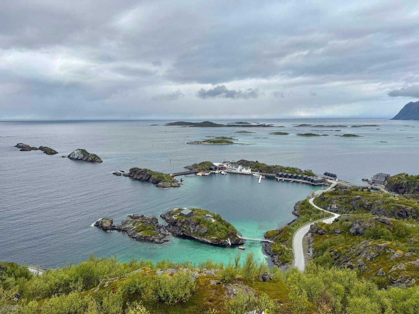
We hiked Hesten specifically because it puts Segla directly in front of you — the full north face, the sheer drop to the fjord, the shape that makes it look like something carved into the coastline. Hesten starts from Fjordgård (very pretty village to walk around if your legs allow after the hike), the same small village as the Segla trailhead.
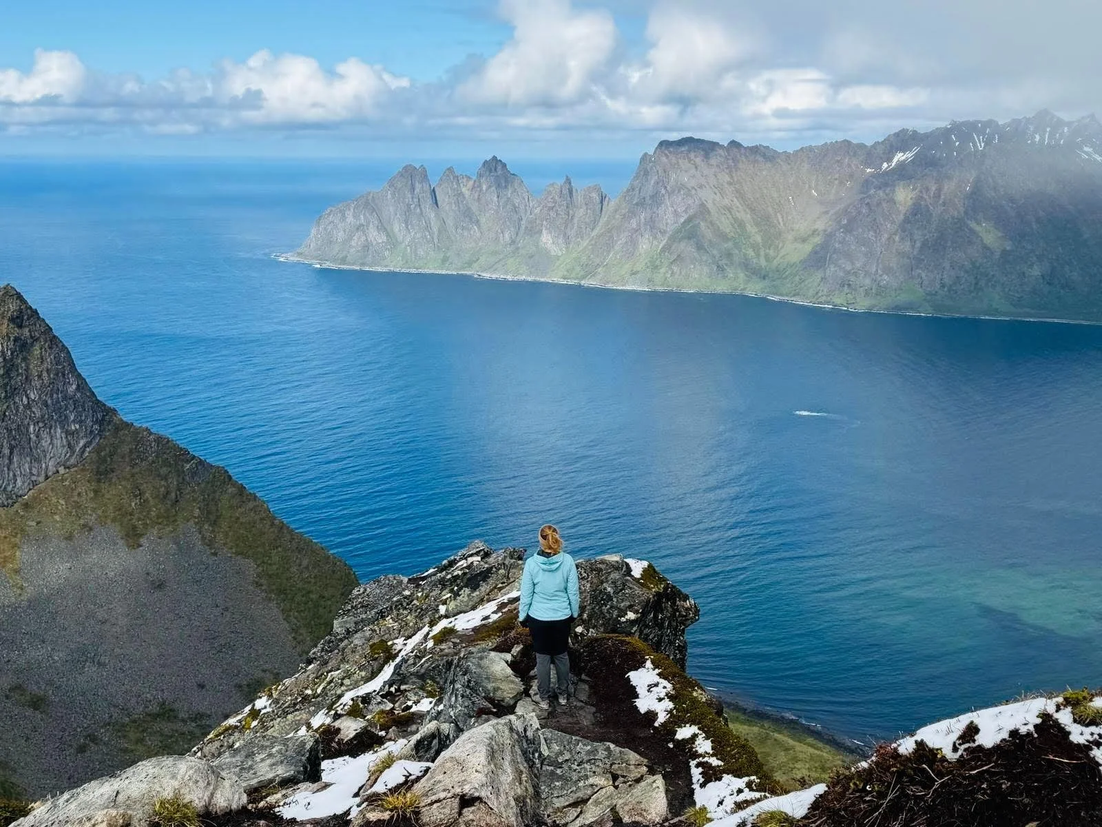
The first section crosses a lovely forest where we saw and heard several ptarmigans. From there the terrain shifts — rockier, until your reach a flat with magnificient views over Segla. Since it was sunny, that’s where we took our photos. We even photographed a ptarmigan who was comfortably chilling on a rock right in front of Segla! Until there, it’s steep but nothing technical. We decided to continue near the edge and climb our way to the top, which involved some scrambling. And we were greeted with… thick clouds. We waited an hour, but clouds kept rolling in and it was getting cold, so we walked back down to the pass between Hesten and Stavelitippen, where the panorama opens over Mefjorden and Øyfjorden with Segla filling the frame.
→ Where to stay near this trailhead: Polar Panorama Lodge in Fjordgård (included in our guide of the best hotels in Senja).

Penguin tip:
If heights make you uncomfortable, you don't need to push all the way to the Hesten summit. The view of Segla from the pass is already extraordinary, and the summit adds exposure and scrambling without much extra scenery. Stop where it feels right.
Hiking Segla, Senja: Norway's most photographed peak
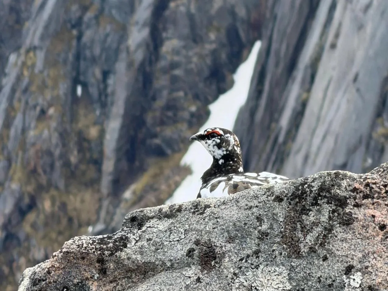
This ptarmigan decided to chill on a rock with a view (on Segla)
📍 Fjordgård, western Senja
Distance: ~5 km round trip | Elevation gain: ~610 m | Time: 3–4 hours | Difficulty: strenuous
We didn't hike Segla — we watched it from Hesten and made peace with that. And from Hesten, Segla looks imposing and frankly crazy to climb. But it's impossible to write a Senja hiking guide and leave it out. It's one of the most searched and most photographed hikes in Norway, and for good reason.
The trail starts from the parking lot behind the Montessori school in Fjordgård. A gravel path climbs steadily to a fork — right for Segla, left for Barden. The western face of Segla is a near-vertical wall dropping to the sea; the ascent comes from the south, which is steep but non-technical. At 636 meters, the summit looks straight down to the fjord.
🐧 Penguin Trampoline tip: Fjordgård is also the trailhead for Hesten and Barden. If you're based here for more than a day, you have three serious hikes from the same village. Do Segla one day, Hesten the next, and Barden if your legs have anything left.
Hiking Husfjellet, Senja: a wilder summit
📍 Skaland, western Senja
Distance: ~8 km round trip | Elevation gain: ~640 m | Time: 4–5 hours | Difficulty: moderate–hard
Husfjellet was our longest day on Senja. The weather forecast was very promising, but we started in overcast conditions and hit snow at the summit — late May. After waiting about an hour at the top, the views finally cleared… and we were so happy we waited. The trail starts from the center of Skaland village, with parking opposite the Joker.
The early section is super easy, with a wide green trail and forest on both sides. The second section gets steeper, and eventually crosses (very) marshy ground on wooden planks through the valley of Sommardalen, then the terrain opens onto the ridge. The upper slopes are rocky and steep, but there's no real scrambling unless you want to explore the different, crazy-looking rocks around. The summit plateau gives a full 360° view: Steinfjorden and Bergsfjorden below, the Oksshornan peaks, small islands scattered across the water, and on a clear day, the Norwegian mainland coast on the horizon.
🐧 Penguin Trampoline tip: We hiked late May and the top was still white. If you're visiting outside peak summer, check trail conditions — the rocky upper section can be icy without warning. Waterproof boots are not optional, and neither is a windproof layer and even a sweater for the exposed summit if you linger for a while.
→ We stayed at Yttersia Base in Skaland, which is right at the Husfjellet trailhead (included in our guide of the best hotels in Senja).
Knuten, Mefjordvær: a midnight sun walk above the village

Midnight late May…
📍 Mefjordvær, northwest Senja
Distance: ~1 km round trip | Elevation gain: ~80 m | Time: 20–40 minutes | Difficulty: easy
Knuten isn't a mountain. It's a rocky hilltop sitting just above Mefjordvær village, a short walk from the harbor. We went up at midnight, after our Husfjellet hike (legs were barely functioning).
Under the midnight sun, the view from Knuten is completely open — fjord on three sides, no trees blocking anything, total quiet. It takes about 15 minutes to reach the top and the path is obvious from the village. Anyone can do this.
🐧 Penguin Trampoline tip: We did this at midnight during the midnight sun season and it was one of the mostmemorable moments of the whole trip. No real effort, nothing to prepare. Just bring a jacket — the wind picks up at the top even on a calm night.
→ We stayed at Mefjord Brygge, which sits at the base of the hill (included in our guide of the best hotels in Senja).
Utsikten, Hamn i Senja: easy Caribbean views
Look at these islands!
📍 Hamn i Senja, western Senja
Distance: ~2 km round trip | Elevation gain: ~150 m | Time: ~1 hour | Difficulty: easy (although it’s marked as blue, which doesn’t happen often in Norway…)
Utsikten means "the view" in Norwegian. The name does most of the work. The trailhead is near Hamn i Senja on the western coast. A short 15-minute climb through forest brings you to a signed junction — left toward the Utsikten viewpoint, or straight to keep going higher.
The viewpoint sits above Bergsfjorden with a panorama of the Bergsøyan islands below, which look almost Caribbean. Well-maintained, clearly marked, and suitable for any fitness level.
🐧 Penguin Trampoline tip: If you continue past the Utsikten junction instead of stopping, the views keep improving. Worth the extra few minutes if you have the time and legs for it.
Other hikes worth knowing about
Ånderdalen National Park contrasts with the rest of Senja
We didn't hike these, but they come up in every serious Senja itinerary.
Barden starts from the same village as Segla — Fjordgård — and is frequently described by people who've done both as the better viewpoint. At 659 meters, it takes around 3.5 hours round trip and gives a full panorama over Mefjorden and Ørnfjorden. Less crowded than Segla, and the obvious choice for a second day when you're already based in Fjordgård.
Breidtinden is the highest point on Senja at 1,001 meters. Steep, exposed, and suited to experienced mountain hikers comfortable on demanding terrain. Not a casual day hike. The summit views are said to be the best on the island — which is easy to believe for a peak that stands 1,000 meters above a coastline this dramatic.
Ånderdalen National Park covers the southern interior of Senja, between Tranøyfjord, Selfjord, and Sifjord — a completely different landscape from the peaks above. Ancient pine and birch forest, rivers, lakes, and a sense of wilderness that reminded us of Finnish Lapland. We walked around the edges of the park but didn't go deeper. The main trails lead to Åndervatnet lake (a relatively flat walk through forest, suitable for all fitness levels) and Kapervatnet (longer and more demanding, around 17km round trip). The park also forms the southern stretch of the Senja Traverse, a 75km multi-day route that crosses the whole island from north to south. Worth knowing about, especially if you're spending more than a few days on Senja and want a contrast to the peak hikes.
Guided hiking tours on Senja

Snow and ice are no jokes on these mountains. In winter, get a guide and gear if you don’t have proper mountaining experience (Husfjellet late May here).
If you'd rather not navigate independently — or if you're visiting in winter when trail conditions require more experience and gear — guided tours are available from both Senja and Tromsø.
Options include a guided hike to Hesten with views of Segla (available in summer and as a snowshoe hike in winter), and a full-day Senja hiking day trip from Tromsø by bus and ferry. You can check Senja hiking tours here.
Small-group options fill up fast in summer — worth booking ahead.
Some accommodations, like Yttersia Base, also offer guided hikes.
Practical tips for hiking on Senja

The Husfjellet trailhead is right on Yttersia Base’s doorstep!
Where to stay. For the western coast hikes (Segla, Hesten, Husfjellet), Fjordgård and Skaland are the most convenient bases. See our full guide to hotels in Senja for all options across the island.
You need a car. There's no meaningful public transport connecting Senja's trailheads. See our guide to renting a car in Tromsø before you arrive.
Norwegian trail difficulty system. Norway's Turistforeningen (DNT) grades trails on a four-tier scale: green (easy, suitable for all), blue (moderate), red (demanding, requires some mountain experience), and black (very demanding). Most of Senja's main hikes — Segla, Hesten, Husfjellet — fall in the red category. If you’re not used to hiking in Norway, always assume it’s going to be more difficult than the level implies.
Weather changes fast. We experienced sun, cloud, wind, and summit snow across four days in late May, which is typical Arctic Norway island weather. Layers, a waterproof shell, and waterproof boots are non-negotiable on the longer hikes regardless of how the morning looks.
Most trails are unmarked or lightly marked. Download an offline map before you head out — AllTrails and Komoot both have the main Senja routes. The Norwegian UT.no app works offline and covers most of the island.
Mosquitoes are real. The lower marshy sections of Husfjellet, Hesten, and Barden can be thick with insects in summer. Insect repellent belongs in your daypack.
What shoes for Senja? For the major hikes (Segla, Hesten, Husfjellet, Barden), waterproof hiking boots with ankle support. For shorter trails like Knuten and Utsikten, trail runners or sturdy shoes are fine, but there will always be some mud at some point. Check our Arctic essentials.
Combine your Senja hiking: Andøya, Lofoten, and Kvaløya
If you're already traveling this far north, it's worth knowing that some of the best hiking destinations in the world (in our humble opinion) are within reach.
Andøya lies just south of Senja — in fact, the Gryllefjord ferry connects directly to Andenes on Andøya, making it a natural extension of a Senja trip if you're heading south. Quieter and less visited than most of northern Norway.
Lofoten is the obvious next stop for hikers, with trails like Reinebringen and Ryten among the most dramatic in the country. We have a full Lofoten hiking guide if you're combining the two.
Kvaløya is the island you pass through on the way to the Senja ferry from Tromsø, and it has its own solid trails. See our Kvaløya guide for more.
✈️ Find flights
🏨 Explore hotels, apartments, guesthouses, cabins
🧭 Browse activities and tours
🚗 Compare car rentals
🧳 Get travel gear
🛡️ Travel safe with Heymondo Travel Insurance (5–15% off)
📱 Get a travel eSIM
🐾 Protect & track Arctic wildlife with Fahlo Bracelets (20% off)
FAQ: Hiking in Senja, Norway
What is the best hike in Senja? Segla is the most iconic — a strenuous 5km trail from Fjordgård to a 636-meter summit with a near-vertical cliff to the sea. For the best view of Segla without summiting it, hike Hesten directly across the fjord. For a longer, wilder experience, Husfjellet near Skaland is hard to top.
Is the Segla hike difficult? Yes. Segla is rated strenuous, with around 610 meters of elevation gain over roughly 5km round trip. The terrain is rocky and steep near the summit, though no technical climbing is required. Fit hikers can complete it, but preparation matters — proper footwear, layers, and water.
Can you hike Hesten and Segla in the same day? You can, but it's a full day. Hesten adds roughly 3–4 hours on top of Segla from the same Fjordgård trailhead. Many people choose one or pair Segla with Barden instead, which is a more manageable combination.
When is the best time to hike in Senja? June to September, when trails are generally clear of snow. Late May is borderline — we hit snow on Husfjellet. July and August offer the most reliable conditions and the midnight sun at the top. Winter hiking is possible on lower trails but requires experience with Norwegian mountain conditions.
Do I need a guide to hike in Senja? No — the main trails (Segla, Hesten, Husfjellet) are well documented and manageable independently with an offline map and proper gear. In winter, guided tours from Tromsø are a sensible option, especially for Hesten under snow conditions.
What shoes do you need for hiking in Senja? For the major hikes, waterproof hiking boots with ankle support. For shorter, easier trails like Knuten and Utsikten, trail runners or sturdy shoes are fine.
How far is Senja from Tromsø? About 2 to 3 hours by car depending on your route. The most scenic approach goes via the Brensholmen–Botnhamn ferry. See our guide on getting to Senja from Tromsø.
Four days on Senja felt like way too short. As in most of Norway, the hikes are not exactly tourist trails — they're steep, often wet at the base, and summit conditions can change within an hour. That's what makes them feel like they're actually earned. We were not alone on the trails, but nothing compared to more touristy Lofoten. Whether you're watching Segla from Hesten at midnight under a sun that won't set, or getting surprised by snow at the top of Husfjellet in late May, Senja is a particular kind of hiking experience that's hard to find elsewhere in Norway, let alone the rest of Europe. It's worth planning for, and worth taking seriously.
Finally, explore all our Northern Norway Travel Guides here.

Free download
Travel Cheaper Cheat Sheet
27 tips on flights, hotels, hidden costs and more — spend less without missing what actually matters.
No spam. Unsubscribe anytime.
Ready to plan your Northern Norway adventure? We’ve got dedicated guides:
🏨 Best Hotels and Cabins in Senja — Including the ones we stayed at.
🥾 Yttersia Base Hotel & Nordisk Bris Restaurant — An authentic base for adventurers on Senja.
⚓ Mefjord Brygge — Historical villas & hotel in a dreamy fisherman’s settlement on Senja.
🏔️ Senja Tour from Tromsø — Explore Arctic peaks, turquoise waters and white sandy beaches with a local.
⛪ Tranøya Island with Senja Moments — Stay on a private island with a long history.
🏙️ Things to See and Do in Tromsø — Our complete guide with local tips.
🏨 Best Hotels for the Northern Lights in Tromsø — Cozy stays, fjord views, and a front-row seat to the Northern Lights.
🏨 Where to Stay in Tromsø — Best areas, hotels, cabins and apartments in the city and beyond.
🌟 Northern Lights in Tromsø — Best time, best spots and is it really a good aurora destination.
☀️ Things to Do in Tromsø in Summer— Midnight sun, beaches, hikes, camping and everything else.
🚗 Renting a car in Tromsø — Pros & cons, ferries, winter driving and everything you need to know.
🦌 Kvaløya, Tromsø’s Backyard— Things to do, hikes, beaches and logistics.
🌌 Northern Lights in Norway — Your guide to clear skies, fjords, and the best aurora spots.
🇳🇴 Alta Travel Guide— Ice hotels, rock carvings, and one of the best places on Earth to spot the aurora.
⛰️ Lofoten Travel Guide — Dramatic ridges, secret beaches, and cod-drying racks in Arctic Norway.
🧖♀️ Bodø, Norway — Things to Do — Floating saunas, sea eagles, and the Arctic city everyone skips (and shouldn’t).